Category:De Knipe
Jump to navigation
Jump to search
| Object location | | View all coordinates using: OpenStreetMap |
|---|
human settlement in the Netherlands    | |||||
| Upload media | |||||
| Instance of | |||||
|---|---|---|---|---|---|
| Location | Heerenveen, Friesland, Netherlands | ||||
 | |||||
English: De Knipe (Dutch, obsolete: De Knijpe) is a village in Heerenveen, a municipality in the Dutch province of Friesland.
Frysk: De Knipe is in doarp yn de gemeente It Hearrenfean.
Nederlands: De Knipe (Nederlands, niet-officieel, verouderd: De Knijpe) is een dorp in de Friese gemeente Heerenveen.
Subcategories
This category has the following 5 subcategories, out of 5 total.
A
B
G
R
S
Media in category "De Knipe"
The following 12 files are in this category, out of 12 total.
-
 Knypstervlag.jpg 500 × 375; 32 KB
-
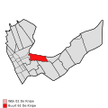 Map - NL - Heerenveen - Wijk 02 De Knipe - Buurt 61 De Knipe.svg 375 × 375; 32 KB
-
 Map - NL - Heerenveen - Wijk 02 De Knipe.svg 625 × 575; 16 KB
-
 Map NL It Hearrenfean De Knipe.png 800 × 500; 66 KB
-
 2023 De Knipe, Meyerwei.jpg 2,585 × 1,723; 1.63 MB
-
 2023 De Knipe, Skoatterlânske Kompanjonsfeart.jpg 2,675 × 1,783; 1.68 MB
-
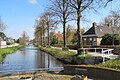
 De Knijpe vaart 02.JPG 1,757 × 1,176; 612 KB
-
 De Knijpe vaart.JPG 1,024 × 768; 183 KB
-
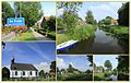 De Knipe een dorp bij Heerenveen in Friesland.jpg 1,832 × 1,157; 762 KB
-
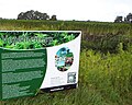 De oogst van vezelhennep.jpg 1,397 × 1,113; 295 KB
-
 Landschap van Jan Mankes.jpg 1,536 × 2,048; 522 KB
-
 Tjeerd Roslaan landhuisje - Oranjewoud - 20177584 - RCE.jpg 1,195 × 1,200; 239 KB


